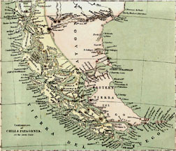
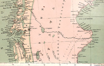
Patagonia, from "The Peoples' Pictorial Atlas"
J. David Williams, New York, 1873
As late as the 1870s, the interior of souhern Patagonia
was practically unexplored and unmapped. The inland areas show only a few
rivers, mountains and lakes, some quite inaccurately. By contrast, the coastal
features are more detailed, the result of decades of hydrographic surveys.
The map also reflects the unsettled nature of the national boundary between
Chile and Argentina. The broad grey line (see images) denotes roughly the
cordillera of the Andes. The lands lying to the east of this line, bounded
to the north by the rivers Limay and Negro, and to the east by the Atlantic
Ocean, are described as "Patagonia: Eastern Chili or Colonial Territory
of Magellan".